Mapping and Visualization
Accurate, up-to-date interactive map visuals for your application.
Azure Maps lets you visualize your data on a variety of map styles. Bring your own data from multiple sources to power your decision making.
Infinitely customizable
Accurate base maps and imagery. Azure Maps gives base maps in a variety of easily customizable formats to help build your application.

Interactive maps
Azure Maps offers high-quality, customizable maps that can be tailored to your application's needs. Whether you're developing for web or mobile, our maps come alive with real-time data, allowing users to explore, understand, and interact with the geographical context at their fingertips.

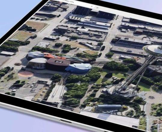
Satellite imagery
Elevate your applications with vivid satellite imagery. Azure Maps brings you closer to the ground with high-resolution images, offering a real-world view that enhances decision-making, planning, and analysis. From urban planning to environmental monitoring, our satellite views provide the comprehensive details you need.

Customizable UI controls
Tailor your mapping and visualization experience with a flexible set of tools and SDKs, allowing you to design and implement user interfaces that fit your application's unique requirements. From map themes to control widgets, you have the freedom to create an intuitive and engaging mapping experience.
Mapping and Visualization
Our comprehensive suite of mapping and visualization features is designed to integrate seamlessly into your applications, providing dynamic, location-based insights with precision and clarity.
Maps Imagery
Azure Maps imagery services offer map imagery in a variety of vector tiles to help provide a base for your application or visualization, allowing you to place a variety of data on your map for anything from vehicle routing to delivery planning.

Maps Visualization
Bring in public or private data to create compelling mapping and visualization. With Azure Maps, you can bring in data stored in your Azure account to create powerful maps visualization to provide clear insights to inform better decision-making.

Building Interactive Maps
With Azure Maps Mapping & Visualization services, you can enable interactive map data visualization for a variety of applications. With Azure Maps SDKs, you can embed it into a variety of surfaces across the web or mobile to create a unique interactive experience for a variety of internal and external users.

Satellite Imagery
Satellite imagery provides real-world views at scale for better understanding – whether that’s evaluating roofs for solar panel installation or the monitoring of vegetation loss. Satellite imagery from Azure can enable mapping and visualization for a range of applications.

More features from Azure Maps

Data and Insights
Leverage Azure Data services to process and analyze large volumes of spatial data to derive actionable insights giving your applications the analysis you need to build better applications.

Location Services
Locate addresses, places, and points of interest around the globe. Geolocate IP addresses or use geocoding to convert addresses to coordinates or GPS coordinates to addresses.

Routes and Directions
Azure Maps offers routing for cars, trucks, and pedestrians, helping you find efficient routes that take into account traffic and local restrictions.
Getting Started Guide
Sign up / sign in to the Azure Portal and start building today.
Technical Documentation
Explore quickstarts, how-to-guides, tutorials, and API reference documentation.
Coding Samples
Visit the Azure Maps web control sample gallery to browse code samples.