

Route Matrix and Route Range
Batch routing, simplified.
Find the best possible routes for multiple sets of locations, and visualize the places your fleet can go based on fuel, time, energy, and more.
Complex routing with pinpoint accuracy.
Designed for efficiency. Calculate accurate travel times for hundreds of destinations with a single API call.
Optimize Everything
Optimize travel times, fuel costs, and energy usage with an API that understands your needs.
Built for Scale
Calculate travel times and distances for hundreds of origins and destinations at a time.
Customizable Parameters
Create streamlined routes for a range of vehicles, including cars, motorcycles, and trucks.
Real-time Data
Leverage the power of real-time location intelligence to avoid road obstructions, traffic, and more.
Multiple Vehicles
Cars, trucks, or motorcycles. Create efficient route ranges suitable for your fleet’s physical dimensions and carrying capacities. Developers can also enter custom parameters for vehicle axle weight and more.
Optimize Resources
Whether your fleet runs on batteries or a standard combustion engine, our API helps you conserve your resources by accounting for your limitations.
EV-Ready
As more businesses transition to full EV fleets, this API adds value to your routes with accurate location data on charging points and travel ranges.
Directions
Tap into Azure Maps’ real-time location intelligence to create smarter routes that avoid traffic and ensure your fleet always arrives on time.
Diverse Applications
Determine the best location for an office based on the distance to public transport and health services, or find the closest possible employee for your clients. Customize the Route Range API’s parameters to suit your needs.
Synchronous and Asynchronous
Submit synchronous requests for immediate and real-time responses, or, create a larger asynchronous request for efficient resource management and larger calculations.
Azure Maps Routing Service
As part of Microsoft’s Azure Maps suite, the routing service uses a massive repository of accurate location data and real-time location intelligence to create a dynamic and dependable routing solution that supports multiple vehicles, cargo types, and more.
Routing APIs
More routing solutions
Directions
Find the most efficient routes based on a single origin and destination. Specify parameters like terrain, vehicle dimensions, and predictive traffic to get the best possible route for your journey.

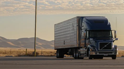
Truck Routing
Simplify fleet logistics with an API designed specifically for truck routing. Traverse dense urban areas with ease, accounting for unique local restrictions and limitations on cargo weight and type.

Ready to start building?

Get started
Our platform provides you with everything you need — from subscription keys for API authentication to a plethora of code samples, demos and SDKs.

Documentation
Complete with code samples, SDK support, and detailed explanations, this is a one-stop resource for enhancing your projects with the wide range of Azure Maps APIs.

Samples
These pre-written snippets show how to perform various API calls for current weather, forecasts, and severe weather alerts, among other functionalities.
Frequently asked questions
-
Getting started with Azure Maps and accessing our matrix APIs is easy. You’ll need to sign up for a free Azure Maps subscription, create an Azure Maps instance, and choose a pricing tier that works for you. You’re all set to start building!
If you’d like to learn more about the service, please contact an Azure Maps expert today.
-
Absolutely! New customers can start building immediately after signing up for an Azure account. With a free $200 in Azure credit and our pay-as-you-go infrastructure, you only pay for what you use beyond our free service limits.
-
Our range service allows users to accurately visualize the set of locations that can be reached depending on a range of parameters, including:
- Fuel
- Time
- Energy
- Distance budget
These data points are visualized through an isochrone, a polygon boundary that covers all reachable locations. Developers can also use our Search Inside Geometry to look for POIs that can be found inside the boundary.
-
Yes, we support up to 700 cells per request for asynchronous calculations, and 100 (number of origins multiplied by destinations) for synchronous calculations. You can learn more about the API and route ranges by checking out the documentation.

Azure Maps
Advanced mapping and visualization features for your applications.
More features from Azure Maps

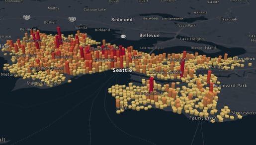
Data and Insights
Process and analyze massive amounts of real-time and historical location data with Azure Data services to find the best possible solutions to logistics challenges.

Indoor Mapping
Build unique and compelling indoor experiences for customers and employees. From tracking indoor assets to navigating venues, indoor mapping has never been easier.

Location Services
Map supply chains, locate POIs, and create customized experiences with powerful geolocation data, all backed by robust search APIs and extensive GIS databases.
Mapping and Visualization
Create varied, fully customizable, and interactive graphs that inform creative decision-making. Experience a new way of visualizing your data.